YELLOW — STANDBY
Palisades Tahoe Village | Contract ASR-1467
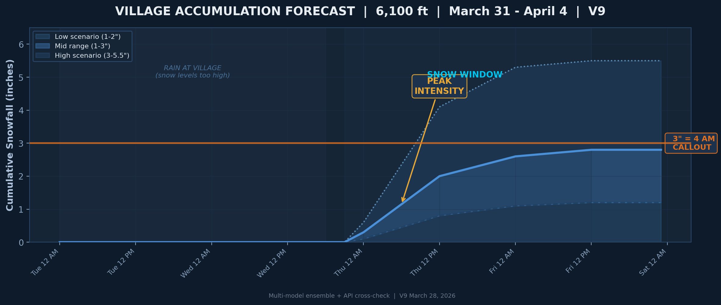
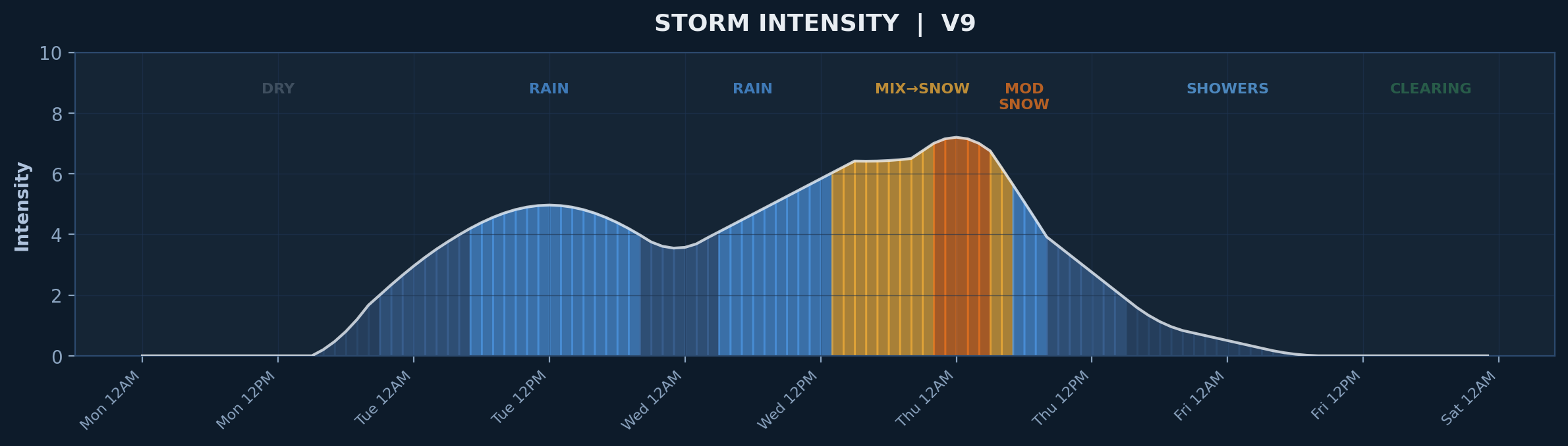
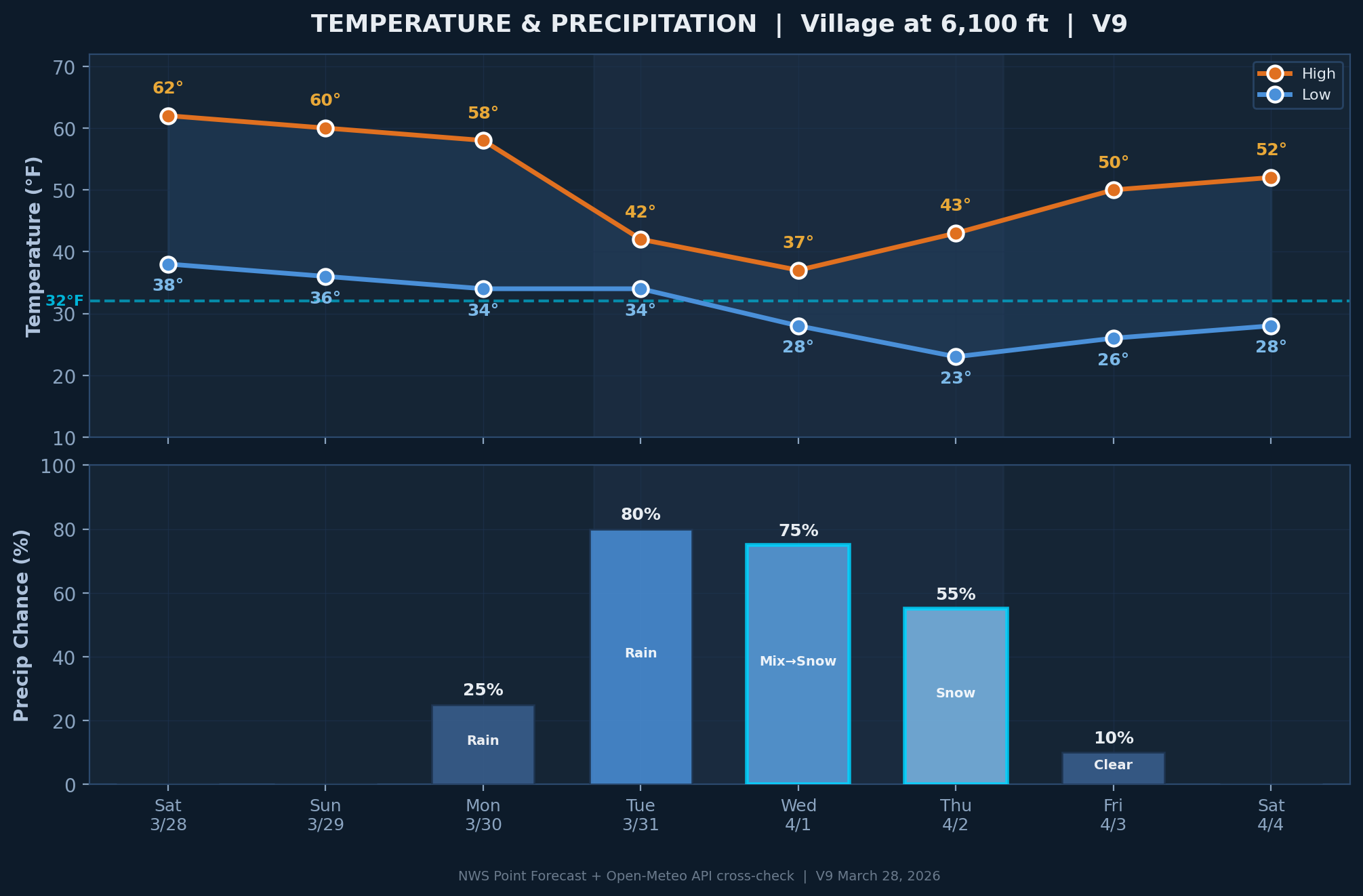
Two-part storm system arriving early next week. Village accumulation revised to 1–3 inches (mid-range). Primary snow window: Wed Apr 1 9PM – Thu Apr 2 noon. 3-inch callout threshold at 35% probability. Decision point: Wednesday 10 PM based on observed snow levels.
Two-part storm system arriving early next week. Village accumulation revised to 1–3 inches (mid-range). Primary snow window: Wed Apr 1 9PM – Thu Apr 2 noon. 3-inch callout threshold at 35% probability. Decision point: Wednesday 10 PM based on observed snow levels.
Live Conditions — Palisades Tahoe Village
6,100 ft elevation | Olympic Valley, CA | Auto-refreshes every 15 minutes
--°F
Temperature
Feels like --°F
--mph
Wind Speed
Gusts: -- mph
--in
Precipitation (24h)
--
--in
Snow Depth
Snow level: -- ft
--mi
Visibility
--
7-Day Forecast
Multi-model composite: GFS + ECMWF + NWS | Updated in real-time
| Day | High | Low | Precip | Snow | Wind | Conditions |
|---|---|---|---|---|---|---|
| Loading forecast data... | ||||||
Storm Reports & Forecasts
Professional multi-model analysis with crew callout recommendations
V9 FACT-CHECKED
Palisades Tahoe Storm Forecast
YELLOW — STANDBY
1–3" Village
35% Callout Probability
View Live Forecast Below →
📊
10 Analysis Charts
Dark-theme matplotlib visualizations
V9 Chart Package
10 Charts
5 Weather Models
Scroll charts below ↓
Forecast Charts — V9
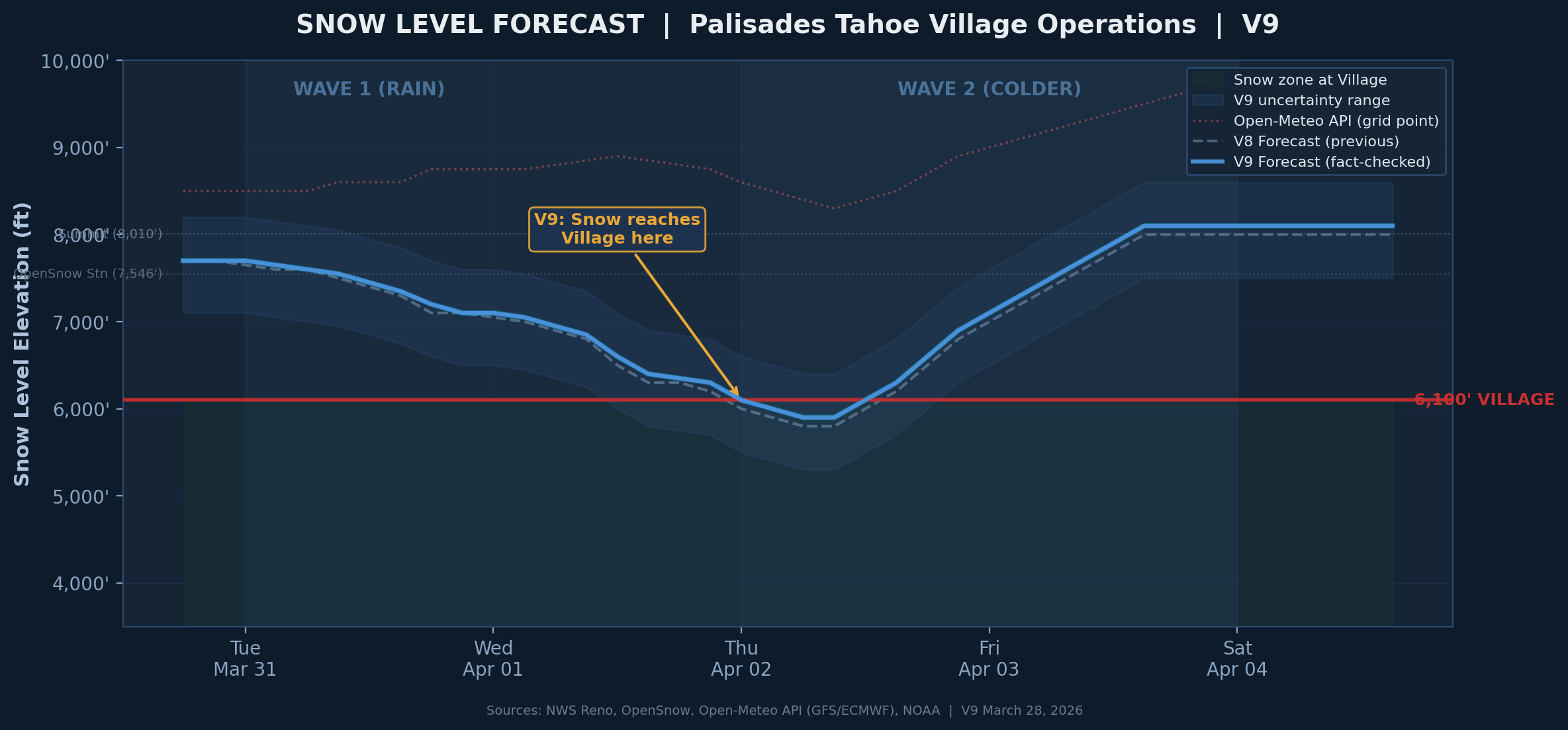
Snow Level Forecast — Oscillation Around 6,100 ft
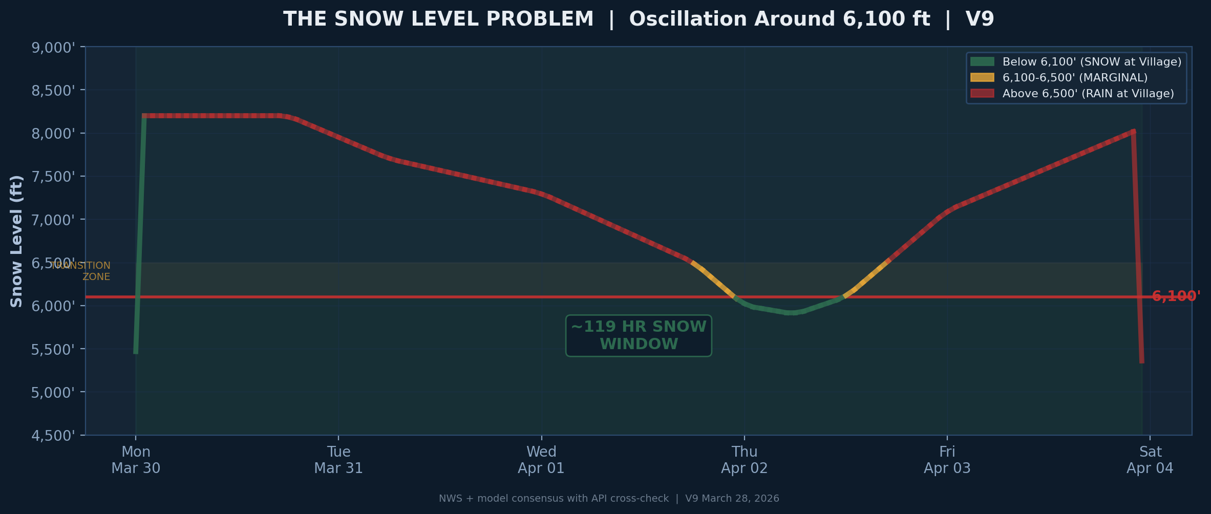
The Snow Level Problem — API vs NWS Discrepancy
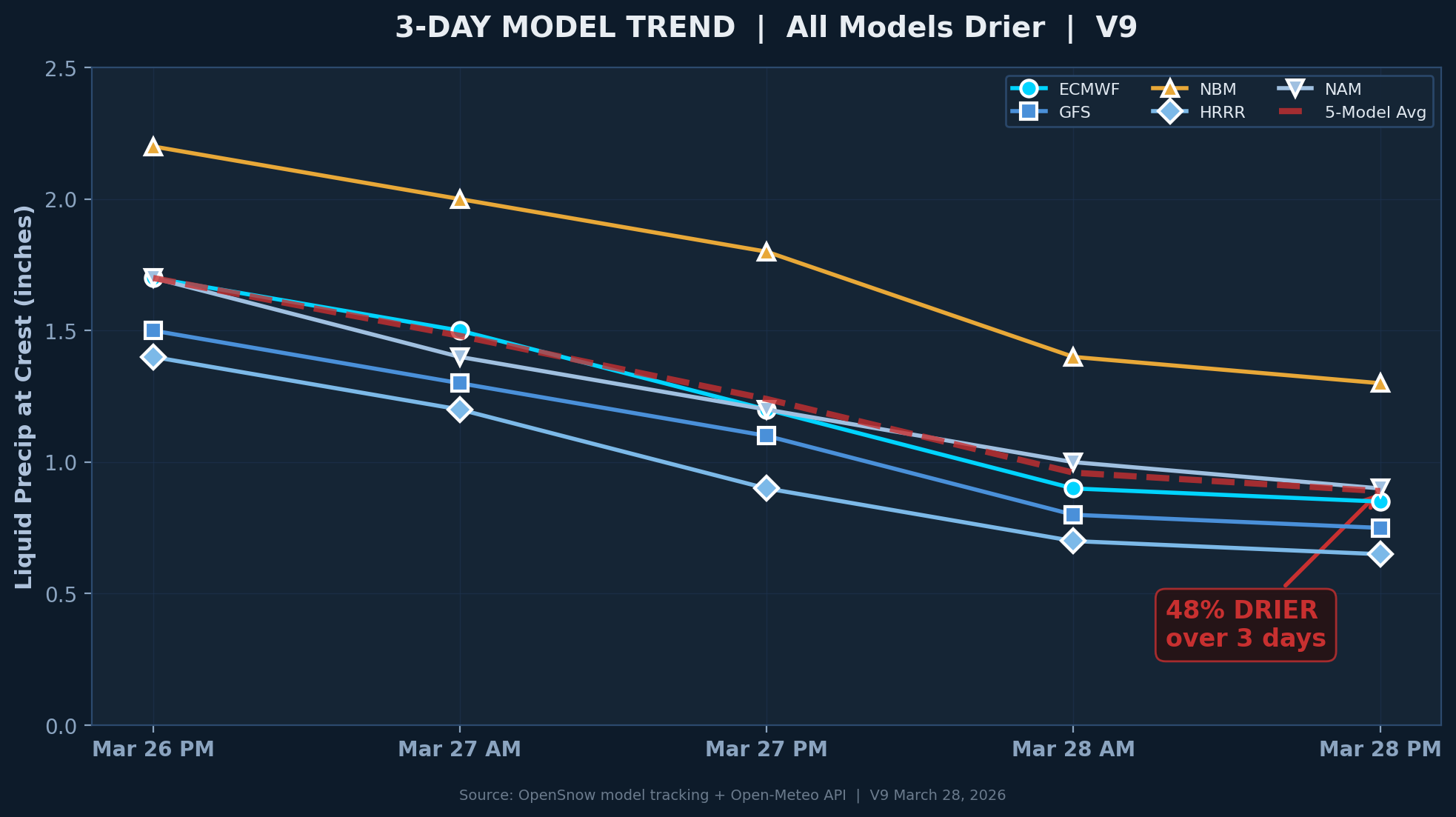
3-Day Model Trend — All Models Drier
Accumulation Forecast — Village vs Upper Mountain
Precipitation Intensity Timeline
Temperature & Precipitation Forecast
Wind Speed & Gust Forecast
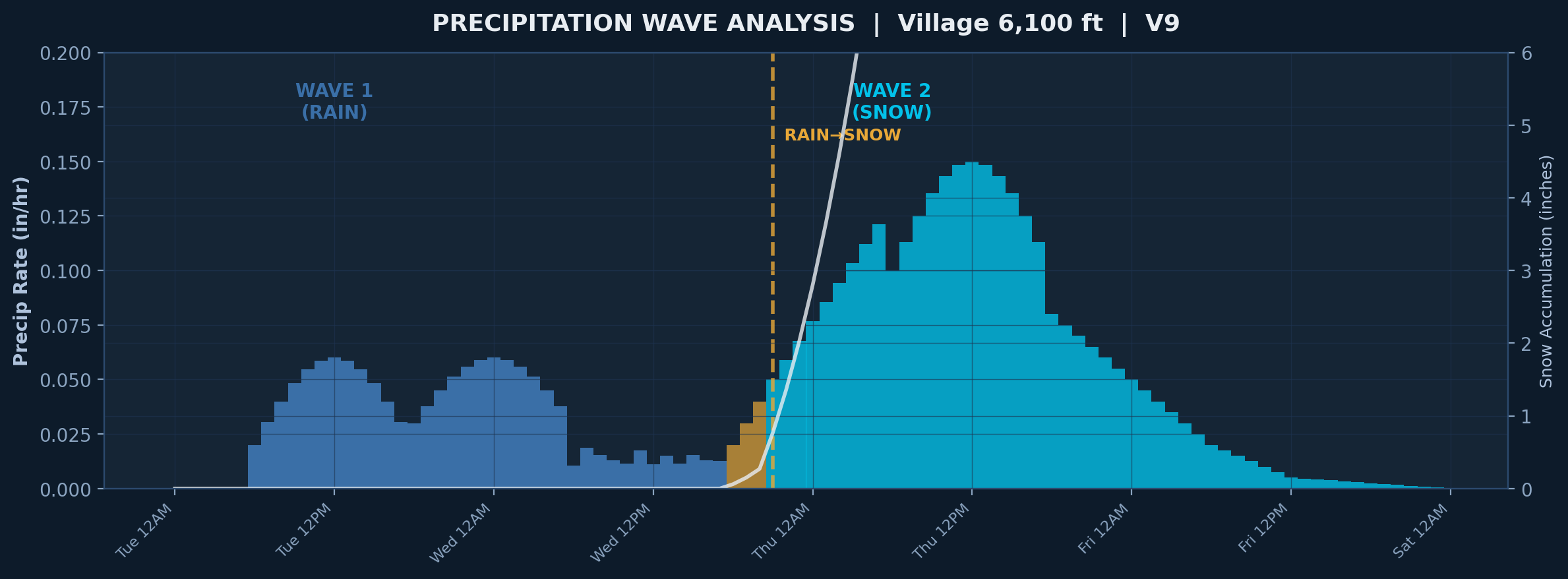
Storm Wave Analysis — Two-Part System
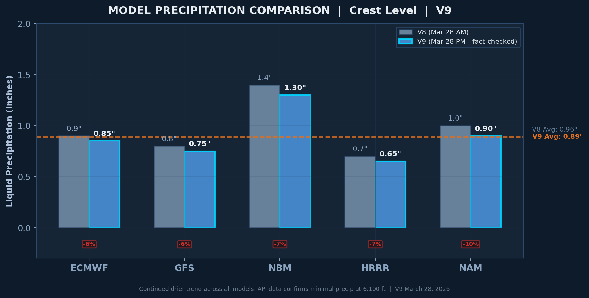
5-Model Comparison — GFS, ECMWF, HRRR, NBM, NAM
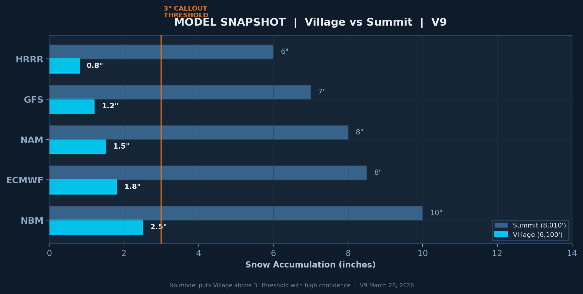
Model Snapshot — Current Run
📡 Live Data Sources
Open-Meteo GFS
NOAA Global Forecast System — US primary model
Open-Meteo ECMWF
European Centre — best skill beyond day 3
NWS Reno
National Weather Service — site-specific human forecast
NOAA SNOTEL
Snowpack telemetry — Squaw Valley GC station
OpenSnow
11-model blend — ski industry standard
CNRFC
CA-NV River Forecast Center — snow levels
🔌 API Endpoints (Developer Reference)
GFS + HRRR Hourly FREE
api.open-meteo.com/v1/gfs?latitude=39.1968&longitude=-120.2354&hourly=temperature_2m,snowfall,snow_depth,windspeed_10m,windgusts_10m,freezinglevel_height
ECMWF Hourly FREE
api.open-meteo.com/v1/ecmwf?latitude=39.1968&longitude=-120.2354&hourly=temperature_2m,snowfall,windspeed_10m,freezinglevel_height
NWS Point Forecast FREE
api.weather.gov/points/39.1968,-120.2354
NWS Active Alerts FREE
api.weather.gov/alerts/active?point=39.1968,-120.2354
Synoptic Mesonet API KEY
api.synopticdata.com/v2/stations/timeseries?stid=KTRK,KSQL&recent=1440&vars=air_temp,wind_speed,precip_accum
Historical Archive FREE
archive-api.open-meteo.com/v1/archive?latitude=39.1968&longitude=-120.2354&hourly=temperature_2m,snowfall,snow_depth
⚠️ Crew Callout Decision Matrix
| Condition | Threshold | Action | Source |
|---|---|---|---|
| Snow on ground | ≥ 3 inches at Village | 4:00 AM CREW CALLOUT | Visual / SNOTEL |
| Freezing level | ≤ 6,100 ft | Snow at Village — monitor closely | Open-Meteo / NWS |
| Wind gusts | ≥ 40 mph | Delay plowing — visibility concern | Open-Meteo / Mesonet |
| Temperature | ≤ 32°F | Watch for ice — salt/sand ready | All sources |
| Precip rate | ≥ 0.5"/hr liquid | Heavy event — all crews standby | NWS / HRRR |
| Snow-to-liquid ratio | 8:1 (wet) to 15:1 (cold) | Adjusts accumulation estimate | Temperature-derived |